A lot of people take for granted that the background scene on the official Guam Seal is Two Lovers Point, or Puntan Dos Amåntes. People look at it and go, "Yeah. Looks like Two Lovers Point." As just one example among many, a recent Fino' Chamorro column in a local newspaper clearly states that the background scene is Puntan Dos Amåntes.
But how do we know for sure it is?
My response is made in this video. But, after the video, I have provided some photos and maps to help explain things.
THE 1917 DESCRIPTION
THE HAGÅTÑA RIVER BEFORE THE WAR
From 1835, we see that the Hagåtña River broke into two directions. One flowed into the bay to the east, to the east of where the Paseo is today, more or less in the same spot the river empties today. The other flow went west towards Aniguak, emptying into the bay across from where the Corn Building used to be.
The same thing can be seen in this 1922 map above.
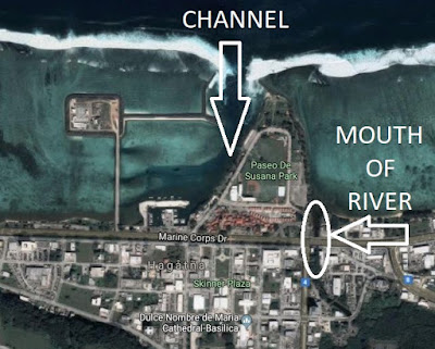
In this aerial photograph of Hagåtña during the American bombardment in 1944, we still see the river empty to the east of the channel. After the American return to Guam, the military bulldozed the destroyed city of Hagåtña and pushed the debris out to sea east of the channel, forming the present-day Paseo, in between the channel and the mouth of the river.
As the pre-war pictorial evidence suggests, the eastern mouth of the pre-war river flowed east of the channel and therefore east of the present-day Paseo. From this location, Two Lovers Point cannot be seen.


No comments:
Post a Comment